previous– Loweswater (United Kingdom) –next
| Lake name: | Loweswater | Country: | United Kingdom | GIG Region: | N |
|---|---|---|---|---|---|
| GIG Type: | LN2a | Lake code: | UK28986 | Altitude(m a.s.l.): | 125 |
| Area (km²): | 0.6 | Mean depth (m): | 8.4 | Mixing regime: | Stratified |
| Alkalinity (m eq/l): | 0.19 | Retention time (yr): | 0.4 | Chlorophyll a (µg/l): | 9.62 |
| Total phosphorus (µg/l): | 16.46 | Eutrophication status: | 2 - Medium | Hydromorphological status: | 1 - Low |
Description
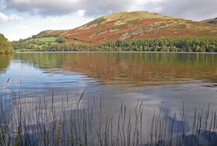
Loweswater is a relatively small lake situated in the north west of the English Lake District. It drains inland (south easterly) towards Crummock Water. The lake has a surface area of 0.6 km2, a mean depth of 8.4 m, a maximum depth of 16 m and a retention time of around 150 days. Loweswater is close to the mesotrophic-eutrophic boundary but probably tending towards being eutrophic.
The hills on the lakes southern shore are wooded and the lake name Loweswater itself derives from the Old Norse for leafy lake. Loweswater is primarily a farmed catchment with much of the land in an agri-environment agreement under the Environmentally Sensitive Area (ESA) scheme. Farming enterprises in the catchment are concentrated on cattle and beef production and this activity has increased over recent decades, particularly in terms of cattle numbers. Since the late 1990s, Loweswater has increasingly experienced cyanobacterial blooms indicative of deteriorating water quality.
back to overview of all sampling sites