previous– Longumvatnet (Norway) –next
| Lake name: | Longumvatnet | Country: | Norway | GIG Region: | N |
|---|---|---|---|---|---|
| GIG Type: | LN2a | Lake code: | 019-10538-L | Altitude(m a.s.l.): | 32 |
| Area (km²): | 0.97 | Mean depth (m): | 9.6 | Mixing regime: | Stratified |
| Alkalinity (m eq/l): | 0.1 | Retention time (yr): | N/A | Chlorophyll a (µg/l): | 5 |
| Total phosphorus (µg/l): | 10 | Eutrophication status: | 2-Medium | Hydromorphological status: | 1-Low |
Description
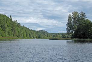
Longumvatnet is situated close to the coastline, 34 m above sea level, in the southern part of Norway. The lake has a surface area of 0.97 km2, a mean depth of 9.6 m and a maximum depth of 34 m and is mesotrophic. The lake is surrounded by agricultural land and forest areas. The lake has a recreational value for the local population and is reserve drinking water supply of Arendal. One of the dominating phytoplankton in this lake was Gonyostomum semen. The macrophytes are dominated by Potamogeton natans, Lobelia dortmanna, Littorella lacustris, and in addition, some Isoetes lacustris and Phragmites australis.
back to overview of all sampling sites