previous– Caramany (France) –next
| Lake name: | Caramany | Country: | France | GIG Region: | Med |
|---|---|---|---|---|---|
| GIG Type: | L-M1 | Lake code: | FRDL127 | Altitude(m a.s.l.): | 170 |
| Area (km²): | 1.78 | Mean depth (m): | 14 | Mixing regime: | Stratified |
| Alkalinity (m eq/l): | ---- | Retention time (yr): | ---- | Chlorophyll a (µg/l): | ---- |
| Total phosphorus (µg/l): | ---- | Eutrophication status: | 1 - Low | Hydromorphological status: | ---- |
Description
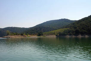
This 10 year-old reservoir is located in the Eastern Pyrénées, in the foothills of the Canigou massif (2785 m). Its true name is Agly's reservoir but it's very close to the village of Caramany from where we can see it. It has been originally created to supply water for agriculture. Nevertheless it's also used in flood control of the Agly river and offers a lot of recreational activities (beaches, angling...). The bottom of this lake is strew with some vineyards and submerged woodland. The lake bed is making by some cliffs or gentle slopes. Its catchment area is dominated by woodland (75% of the surface) and in a lesser extend by agricultural land use (23%). The environmental characteristics of this reservoir are not known.
back to overview of all sampling sites